

Snow, wind & bitter cold temperatures hit Puget Sound region
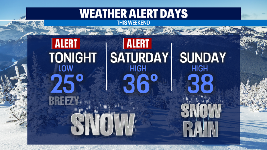
Seattle - Another "Weather Alert Day" is in place for Saturday as snow continues to fall across Western Washington with freezing rain and sleet at the coast.
Heavy snow and wind were causing power outages. As of 6:30 a.m. Sunday, there were more than 20,000 people without power, according to Puget Sound Energy, Snohomimsh County PUD and Grays Harbor PUD.
Our winter wonderland will last through the weekend with the bulk of our snow showers fading away Saturday afternoon, but don't be surprised if we see spotty showers through the evening.
WATCH Q13 NEWS THIS MORNING ON JOEtv (CABLE 10/CH. 22) 7-11 A.M. FOR LIVE WINTER WEATHER COVERAGE
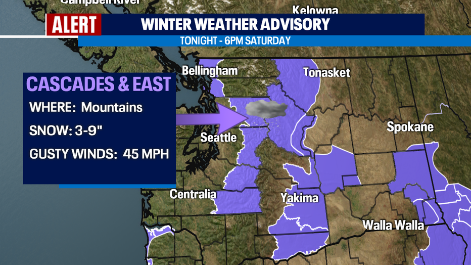
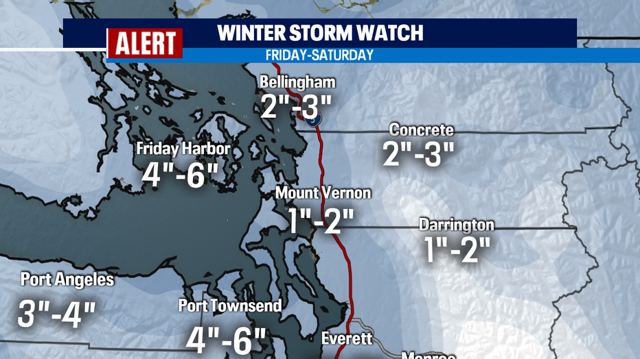
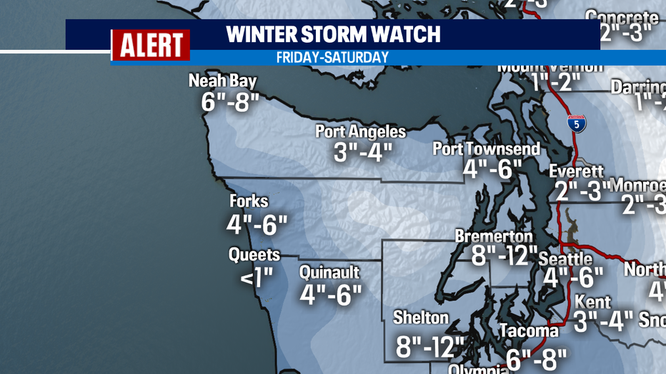
The "Winter Storm Warning" stays with us through tomorrow midday along with a "Winter Weather Advisory" for the North Sound and through the Cascades.
Traveling through the mountains will be very tricky at times, especially with temperatures overnight in the single digits. Make sure to check in with our Q13 Weather App for the latest details.
GET THE Q13 WEATHER APP TO TRACK HEAVY SNOW AND BELOW FREEZING TEMPERATURES
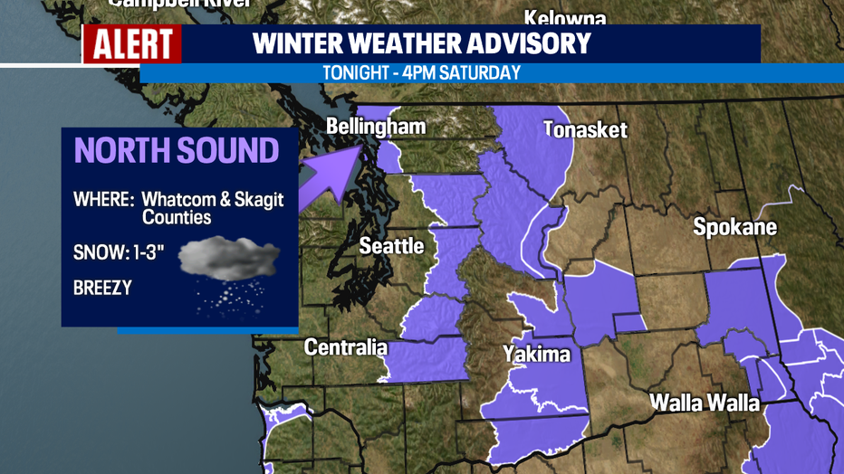
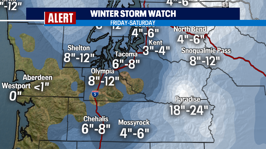
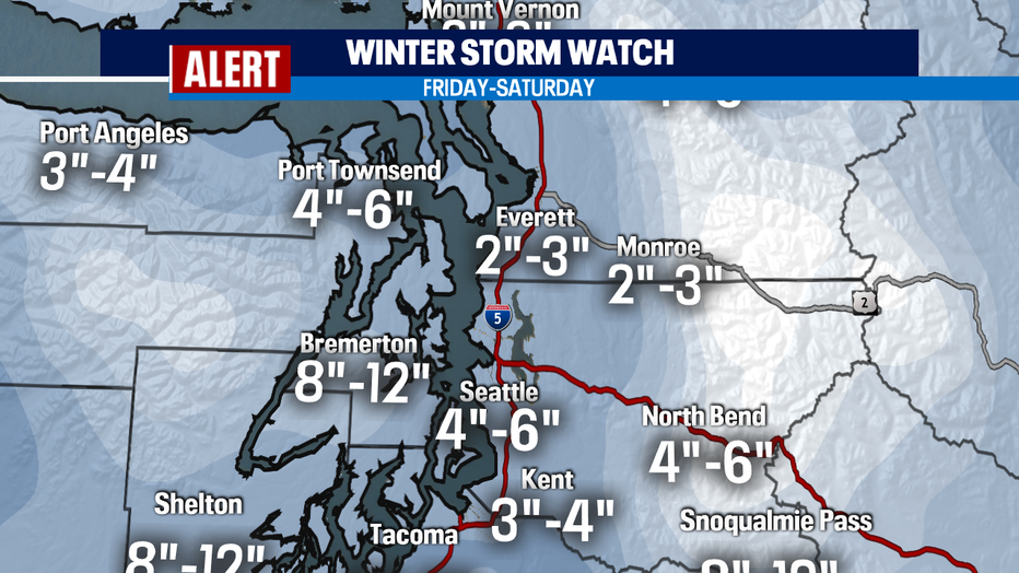
Alright, now to our snow totals! The South Sound definitely seeing impressive totals with snow coming down since yesterday. Also, Kitsap County in the Hood Canal area totals will climb with less amounts to the North Sound for Skagit and Whatcom Counties. Here's a look at what our Q13 Weather Team is predicting.
RELATED: Be winter-ready: 4 important NW winter driving reminders
Our winds have settled down some, but we'll stay pretty breezy for Saturday and this will keep our "Feels Like" temperatures very cold.
CHECK THE LATEST WEATHER ALERTS
We expect highs to climb into the mid 30s Saturday, increasing to the upper 30s Sunday and finally jumping back into the low 40s to start the week. As the warm ocean air fights to push inland our cold air sitting over much of Western Wa will try to hang on, but what we'll see is a snow/rain mix the deeper we get into the weekend. Sunday has a chance of snow, but by the end of the day warmer temperatures will take over opening the door for more rain to fall.
As snow melts and we transition back to rain there is the potential for "Urban Flooding" around the region. Make sure drains are clear of debris. We expect a decent amount of water to be flowing through neighborhoods and city streets.
Moving into next week snow levels will start to rise near 2,000ft with temperatures pushing above freezing. We will stay active with a series of systems rolling in off the Pacific. While the lowlands will see rain we expect heavy snow in the mountains.
RELATED: Storm cancels several COVID-19 testing and vaccination sites across Western Washington